0.15 miles long. One measly block. From South Avenue / Union CR 610 in Cranford, to an underpass of the Raritan Valley line, only to end at NJ 28. The only reason why NJ 59 exists is because it should have done a lot more. This should have extended south to Rahway, and north to where NJ 159 currently is. There's an interesting coincidence around NJ 159 and NJ 59, because both routes were supposed to connect. But no. NJ 59 is far south of NJ 159, NJ 159 is longer than NJ 59, and neither route connects. At least NJ 59 is four lanes throughout its short length.
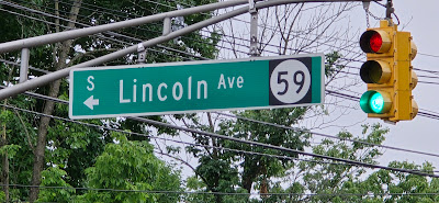
The southern end of NJ 59 at South Avenue (CR 610). The overhead sign blade for Lincoln Avenue is up to NJDOT specifications (despite not having an NJ 59 shield), indicating an NJDOT facility.
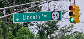
At the same intersection. This overhead is not up to state specifications, as shown by font type, letter spacing, and county route shield design.
A sign for Union CR 610 at the southern terminus of NJ 59.
This might be state-standard curb (at the time it was built). NJ 59 is four lanes for its short length.
Passing under the Raritan Valley Line. The green sign at the bottom might be another indication that NJ 59 exists and is state maintained at the rail underpass (but then again, any over or underpass of NJ Transit facilities is state maintained, isn't it?)
Looking north from the southbound lanes at the northern terminus of NJ 59. This gore is where turns from NJ 28 converge to form the brief, four-lane NJ 59.
This concrete guiderail indicates the former designation of NJ 59 as NJH 22, a route intended for much more.
The northern terminus of NJ 59 at NJ 28. These signs are up to state specifications, indicating state maintenance.
Overhead, state-spec sign blades. The NJ 59 overhead is the only signage that exists for this short state highway (I mean, underpass).
Cranford signs their streets with these stone poles, and the NJ 28/NJ 59 intersection is no exception.

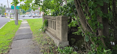

The only proof NJ 59 should have extended much further out is this 1930s-era concrete guiderail, and a grassy graded area. The guiderail has an angle that is inclined to current NJ 59, and there is some graded area indicating a northern extension that should have been built. But it never happened.

Looking southbound at modern NJ 59 from the graded area.
And here it is. Whatever additional length there was supposed to be for NJH 22 / NJ 59 is evident here. The road would have cut through multiple neighborhoods had it been built.
And there it is. The northernmost indication of any state highway that should have been NJ 59. The unbuilt stub of NJH 22.


.jpg)


No comments:
Post a Comment