

CR 656 is the northernmost segment of Ocean Drive in Cape May County. The route is considered east-west by Cape May County and NJDOT (and the route has a northeast-southwest tilt), but there are signs suggesting CR 656 is north-south (the main compass direction).
The road has local names. However, the seagull signage continues Ocean Drive.


At the intersection with 9th Street, which becomes NJ 52 just north of here. Oddly enough, NJ 52 doesn't begin at this intersection, but at the foot of the Stainton Memorial Causeway, even though 9th Street is the effective end of NJ 52.

An old CR 656 shield.

.jpg)


The toll plaza for the Ocean City-Longport Bridge. Tolls are charged to enter, but not exit, Ocean City.


Per NJDOT, CR 656 ends at the border of Atlantic and Cape May County.
Per a 2020 map of Cape May County roads, CR 656 extends into Atlantic County to end at NJ 152. Atlantic County doesn't have an Atlantic CR 656, and they don't recognize Cape May CR 656 until it crosses into Cape May County.
I'll still have photos of the Atlantic County side anyways, where the road name transitions into Ocean City - Longport Boulevard or Ocean Drive.


Ocean City-Longport Boulevard comes to a parking area for the Ocean City-Longport Bridge Fishing Pier. The fishing pier uses the northern remnant of the 1944 Ocean City-Longport Bridge.


Because signs will spoil the view from the bridge, the toll signs are posted on the approach, even if access to the parking lot is free.
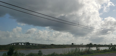
The bridge as viewed from the approach.

Signage for another county's CR in Atlantic County. But this is acceptable, because Ocean City-Longport Boulevard doesn't connect to anything other than Cape May CR 656. I'm surprised Atlantic County hasn't created its own CR 656 to connect with this, or extended CR 629 down to Ocean City on the Boulevard.
No comments:
Post a Comment